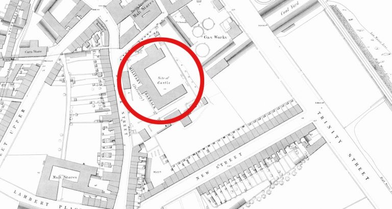
Map of historical sites in Wexford
An interactive map pinpoints historical sites in Wexford Town, highlighting Viking and Norman heritage with locations of town wall sections, ruined churches, and structures that no longer exist.
Page 3 of 5
An interactive map pinpoints historical sites in Wexford Town, highlighting Viking and Norman heritage with locations of town wall sections, ruined churches, and structures that no longer exist.
A medieval leper hospital and church lie hidden behind a wall in Maudlintown, Wexford Town. Established in 1176 and possibly founded by Strongbow, the site was suppressed during the Dissolution of the Monasteries.
St. Peter’s Church once stood on what is now Peter’s Square in Wexford Town.
Folk tales from rural County Wexford describe men becoming lost at night, including a farmer who believed he could only find his field gate after removing his shoes and socks.
Completed in 1858 as a Crimean War memorial, the round tower in Ferrycarrig, County Wexford, is often mistaken for a genuine medieval Irish round tower.
Wexford photographer Des Kiely’s comparison photographs pair historical and present-day views of Wexford Town’s streets and landmarks.
Oliver Cromwell’s nine-day siege of Wexford Town in October 1649 ended with the storming of the town and a massacre of hundreds after negotiations with Governor David Sinnott broke down.
Carrig Graveyard is the final resting place for many who died during the Irish Rebellion of 1798.
George Griffith’s 1877 book ‘Chronicles of County Wexford’ documented a century of change in the county’s postal service, from three post offices in 1777 to 56 by 1877.
Rathaspeck Church holds the grave of United Irishman Cornelius Grogan, executed in 1798. The church closed in 1971 but received a €100,620 restoration grant in 2025.